From this perspective, remote sensing sensors capture specific information (light or Electromagnetic radiation) from the object (or region) of interest. With this information, we can further decide or enhance our knowledge of the relevant field of study. For example, a weather satellite can acquire remote sensing images, and by algorithmic processing, relevant atmospheric parameters can be obtained, which ultimately can drive decisions. In general, remote sensing sensors (mainly specialized cameras) do not directly measure the information of our interest but record data from which the desired information can be extracted or correlated using some advanced algorithms.
The electromagnetic spectrum encompasses a vast range of electromagnetic radiation arranged to measure on either frequency or wavelength. This radiation travels in waves, varying from very short gamma rays to extremely long radio waves. While our eyes can only detect a tiny portion of this spectrum, known as visible light (see the rainbow in Figure 1), other parts, such as ultraviolet or infrared rays, are beyond human visual perception. Instruments, however, have been developed to detect these unseen wavelengths, leading to several applications, such as Remote Sensing. The comprehensive understanding of the electromagnetic spectrum has been pivotal in advancing modern science and technology.
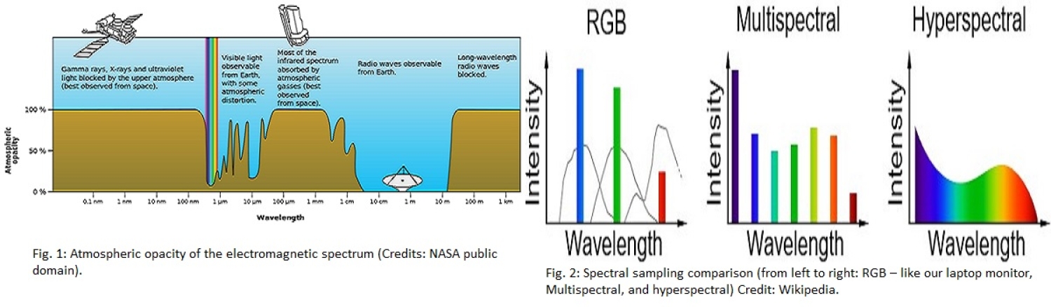
The electromagnetic spectral region observed by multi- and hyper-spectral sensors is a small portion of the full spectrum, usually ranging from 0.4 to 2.5 μm. The light that our human eyes can see falls in the range around 0.4 to 0.7 μm. Wavelengths larger than 0.7 μm we call it infrared light. The fact that these sensors are sensitive in this portion of the spectrum lies with the atmospheric conditions of our planet (see Fig. 1). The Earth’s atmosphere allows (transmitted) and blocks (absorbed) specific ranges (or bands) of wavelengths. Optical and certain infrared bands can go through the Earth’s atmosphere, allowing Earth observations in these wavelengths. The transmitted wavelengths reach the Earth’s surface and then are reflected by it. The Multi- and hyper-spectral sensors record the reflected radiation from the Earth through the atmosphere. Most remote sensing satellites are at Low Earth Orbits, typically a few hundred kilometers above average sea level.
Different objects (or materials) reflect and emit light differently. The reflected light from the surface interacts with each material differently, and even the smallest variations of it can be quantified and recorded through multi/hyperspectral imagery. The result of this light-to-object interaction is called the spectral signature and is considered a “fingerprint” of each object. Most methods and techniques in hyperspectral remote sensing are based purely on the detailed spectral signatures that the instrument records.
There is a difference between Multispectral and Hyperspectral imaging detectors in remote sensing. For comparison, let’s consider the usual Red-Green-Blue (RGB) composite we are most familiar with (e.g., the pixel of your laptop screen). Based on the RGB sampling, you can recreate any color (wavelength) based on the relative value of each RGB color. On the contrary, a Multispectral detector captures data in several (typically between 3 and 10) discrete, broad wavelength bands. Furthermore, the Hyperspectral detector captures data in a large number (often a few hundred) of almost contiguous, narrow wavelength bands. Fig. 2 compares the RGB composite, multispectral, and hyperspectral. A hyperspectral image provides the most detailed spectral information for every pixel in the picture.
We can consider a few examples regarding the application between Multispectral and Hyperspectral Imaging. Given its fewer bands, multispectral imaging is often used for broad-based analyses like land cover classification, vegetation health monitoring, and water body detection. On the contrary, Hyperspectral Imaging is suitable for more detailed tasks like mineral exploration, crop disease detection, and identifying specific chemical compounds in a scene due to its very high spectral resolution. While multispectral imaging gives a broader overview of a scene across a few bands, hyperspectral imaging delves deep into the spectral details. The choice between them depends on the specific application and the level of detail required by the definition of the mission at an early phase.