This project aims to enable the advanced adoption of satellite earth observations by public and private organizations to benefit food security and agriculture [1]. Soil moisture is a vital variable for monitoring crop health and predicting yields. Plants use water for temperature regulation, and a lack of water in the soil can negatively impact a plant’s ability to reach its potential growth. Low moisture in the agricultural land means decreased crop productivity or smaller yields. Therefore, to ensure food security around the globe, it is important to monitor the croplands and take proper precautions. The NASA Harvest team members have been developing new methods of monitoring soil moisture using a combination of machine-learning models and satellite-based radar waves [2].
The team used a variety of radars called interferometric synthetic aperture radar (InSAR). It is a technique where transmitted radar waves are bounced off a target surface, and an image is produced based on the power of the wave received by the sensor and by measuring the time it takes for the waves to return to the satellite sensors [3].
One application of the InSAR technology is monitoring the Topsoil Moisture in the United States. The InSAR data was collected from both space-borne sensors (ESA’s Sentinel-1) and sensors attached to UAVs. For instance, the soil moisture levels in Washington State are at their lowest point of the 21st century. These critically dry soils are projected to impact agricultural production in the state severely.
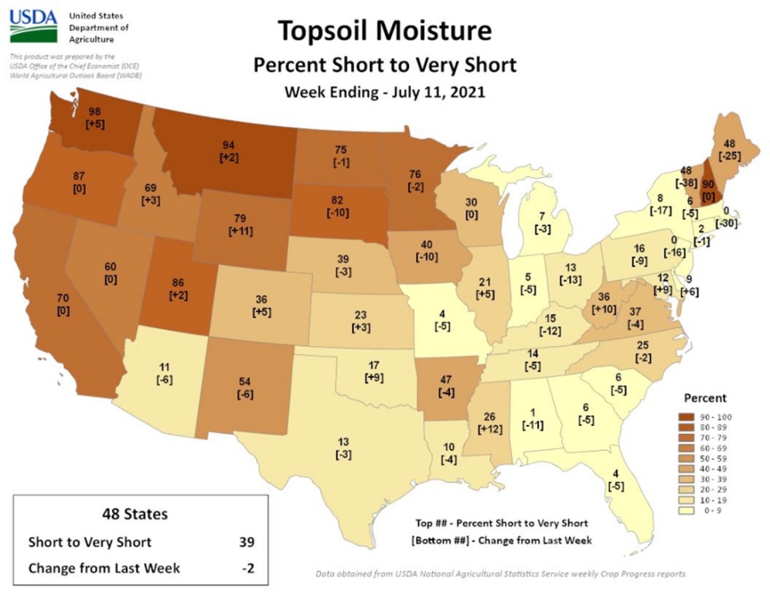
Figure 1 shows the map of topsoil moisture measures across the US. Out of 48 states that were studied, around 39 states are considered in the Short to Very Short moisture level. A Short moisture condition is described when the top and the sub-soil are dry, and the seed germination could be reduced. A Very Short moisture condition is when the soil moisture is significantly less than required for normal plant development [4].
Such new techniques for earth observation are critical for food security and agriculture. These findings provide further evidence of the potential for InSAR to be used for soil moisture estimation and will help design new soil moisture monitoring systems as we advance.
References:
- Harvest, https://nasaharvest.org/ (accessed Oct. 26, 2023).
- “Monitoring soil moisture over agricultural fields using synthetic aperture radar,” Harvest, https://nasaharvest.org/news/monitoring-soil-moisture-over-agricultural-fields-using-synthetic-aperture-radar (accessed Oct. 26, 2023).
- Ramakrishnan, S., Demarcus, V., Ny, J.L., Patwari, N., & Gussy, J. (2002). Synthetic Aperture Radar Imaging Using Spectral Estimation Techniques.
- Z. (This email address is being protected from spambots. You need JavaScript enabled to view it.), “References, definitions, acronyms, and abbreviations,” Crop-CASMA User’s Guide, https://nassgeo.csiss.gmu.edu/Crop-CASMA-User/user/references/ (accessed Oct. 30, 2023).